Slideshow:

The floodplains of the River Thames are characterised by high land prices and intense urbanisation, with few options for creating extra flood storage. A number of tributaries of the fluvial Thames suffer localised flooding in urban reaches, affecting local inhabitants, businesses, property and infrastructure.
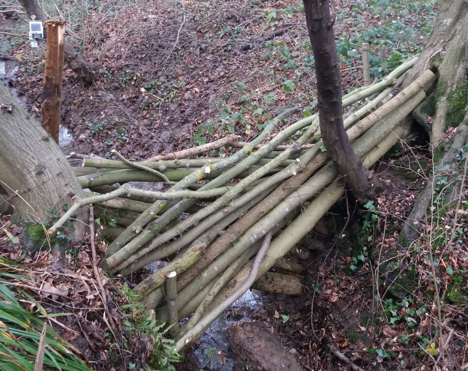
Recently there has been UK government investment in natural flood management (NFM) and there is growing interest in how land management such as Conservation Agriculture can provide water management for storing flood water as well as biological benefits. NAIAD is investigating the effectiveness of leaky dams, beaver dams, conservation agriculture and retention ponds in reducing downstream flood peaks. ‘Effectiveness’ means how well the intervention mitigates the hazard and prevents loss.
The Eco:Actuary toolkit is a suite of tools developed to support risk analysis for natural hazards, investment planning for natural flood management (NFM), assessment of co-benefits and effectiveness monitoring for installed interventions.
The toolkit comprises three key components:
- The //Smart:River and //Smart:Soil systems for in field monitoring and web-based analysis of the effectiveness of specific interventions made.
- The Eco:Actuary web-based Investment planner - which is an empirical tool for understanding the magnitude and type of interventions necessary to make a significant difference to observed flood peaks within a set budget. Flood peak data are provided for application in England using the real time Environment Agency flood and river level data
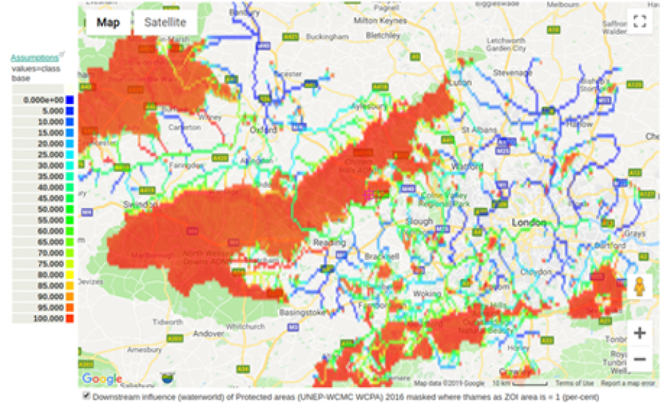
- The Eco:Actuary web-based spatial policy support system - which maps risk, exposure, and avoided loss for current natural capital and mitigation scenarios for climate, land and nature-based solution investments. All data are provided for application anywhere, globally.
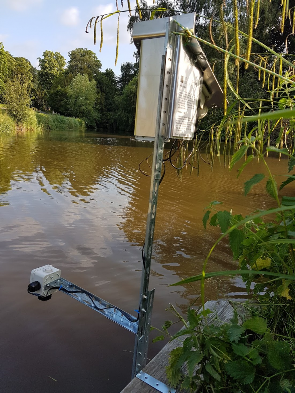
Freestations are web-connected, low cost, open source environmental monitoring equipment. They are designed to make reliable, detailed and local environmental data more accessible in areas that may have little local financial and technical capacity for the collection of such data. More information: freestation.org
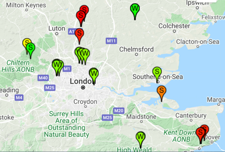
We have deployed water level FreeStations and soil moisture FreeStations in small catchments throughout the southeast and Midlands of the UK for monitoring the effectiveness of specific in-place NFM as part of the NAIAD project (see maps).
- Developing climate change adaptation; improving risk management and resilience
- Reduce drought risk
- Reduce flood risk
- Reduce risk of damages from drought
- Increase awareness of NBS solution & their effectiveness and co benefits
- Increase stakeholder awareness & knowledge about NBS
- Increase willingness to invest in NBS
- Social learning about location & importance of NBS
The //Smart: system consists of a series of web connected sensors (FreeStations) designed to monitor NFM effectiveness to assess the contribution of NFM to mitigate flooding. The //Smart: System has two main applications in the Thames basin:
//Smart:River, for:
- Examining stage in relation to rainfall events
- Comparing stage either side of an intervention
- Examining storage relative to a downstream flow gauge
and //Smart:Soil, for:
- Calculating soil storage relative to a downstream flow gauge
- Calculating the marginal impact of a soil management intervention
- Calculating soil water fluxes
//Smart: is intended as a turnkey system and is used to monitor the effectiveness of specific in-place NFM accurately, at low cost and with ease. It comprises self-build open source hardware alongside on-device firmware and server-side software for near real-time monitoring and assessment of NFM including point source in-line storage (leaky dams, retention ponds) and non-point land management options such as conservation agriculture. //Smart: enables live website links on the contribution of NFM, for example the Beaver dam project live link at Spains Hall Estate, one of the NAIAD sites.
//Smart: is accurate, low cost and easy to implement. Investors in NFM such as local Government and conservation organisations can easily assess the best options for investment. It can be applied anywhere in the world so it has a global benefit.
Eco:Actuary is being used to map risk, exposure, loss, mitigation and avoided loss for current natural capital and scenarios for climate change and nature-based solution investments.
Eco:Actuary in Thames demonstrates that:
- Small scale interventions will have little impact downstream,
- Not all interventions will work for all events,
- We still need insurance - the smaller the intervention, the fewer events that it will protect from.
- The sum of all interventions upstream of assets is what matters,
- Interventions cannot be considered in isolation from each other,
- Where you put the intervention in the catchment is also important,
- Small (or more) interventions should be located towards the top of catchments,
- larger interventions should be located further downstream (where rivers have greater flow), or nearer to assets where their impact can be greater.
An advantage of NFM is that they have co-benefits which grey infrastructure solutions do not. Co-benefits include biodiversity and other ecosystem services such as carbon, recreation etc.
Grey infrastructure may have co-disbenefits, such as higher resource costs, aesthetics etc. NFM also have opportunity costs, e.g. for agricultural production of retention ponds. There may also be risks for NFM, e.g. for water resources and dry season flows of more storage in the landscape and thus more water loss to evapotranspiration (the sum of evaporation and plant transpiration from the Earth's land and ocean surface to the atmosphere). Geography (context) and position in relation to assets at risk and potential beneficiaries of co-benefits is critical.
NFM are not engineering solutions and thus different methods are required to determine :
- how much extra flood storage is needed in the landscape,
- where the flood storage should be located to be most effective. Investors and planners can investigate this using the Eco:Actuary web-based Investment planner for understanding the magnitude and type of interventions necessary to make a significant difference to observed flood peaks,
- and how effective the NFM are for different events – for example using the //Smart: system with FreeStations, investors and planners can use the spatial Eco:Actuary Policy Support System to help assess the downstream flood damage losses that are mitigated.
This project has received funding from the European Union’s Horizon 2020 research and innovation programme under grant agreement No 730497.
NAIAD aims to operationalise the insurance value of ecosystems to reduce the human and economic cost of risks associated with water (floods and drought) by developing and testing – with key insurers and municipalities – the concepts, tools, applications and instruments (business models) necessary for its mainstreaming.
- 13. Climate Action