Utrecht - NbS for for urban resilience and citizens’ wellbeing
Utrecht is the fourth largest city in the Netherlands. It is a transport ’hub’ with highways, rivers and railways passing or transecting the city, presenting one of its biggest spatial challenges (Green Surge, 2015). In addition, Utrecht is the fastest growing city in the Netherlands; its population is expected to grow from 330 000 inhabitants in 2017 to 400 000 in 2030.
Due to densification, pressure on Utrecht’s public green space is increasing. With an eye to climate change and quality of life — and within its vision of healthy urban living — Utrecht aspires to optimise and utilise ‘green’ and ‘blue’ (land and water) infrastructure as much as possible both to face the consequences of climate change and to face health, sociocultural, economic and environmental challenges.
With a green and blue framework that supports ecosystem benefits, Utrecht aims to promote healthy urban living through an integrated and systemic approach that combines local climate regulation, noise reduction, recreation and cleaner air. Currently, its main instrument for protecting and improving green space is the 2007 Green Structure Plan.
Green Structure Plan actions aim at sustainable urbanisation: less and slower traffic, climate- and energy-neutral construction, efficient water management and green areas for pleasant and healthy urban living. Utrecht wants to be a city where a healthy living environment and sustainable growth are core values. The updated Green Structure Plan 2017-2030 aims at making better use of green and blue infrastructure and restoring ecosystems. For instance, the role of trees in improving air quality, reducing urban heat island effect, and capturing CO2; or the positive influence of living nature for a healthier city, are some of the benefits foreseen by the Plan (UGSP, 2017).
Another key to boosting green space is the 2009 tree policy. This explains how the city uses trees in urban development. Trees are considered to have their own spatial dimension and problems that merit specific policy on such matters as tree structure, instruments, and guidelines for their management and maintenance (Green Surge, 2015). This is based on the ecological, recreational, cultural-historic and spatial values of urban green space in and around the city.
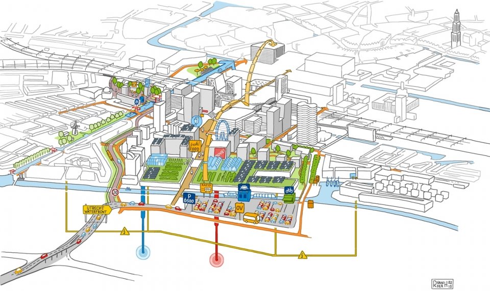
The new Central Station Area is one of the Netherlands’ major transformation projects and is included in the Smart Sustainable Districts (SSD) consortium as part of the Climate-KIC initiative. Nature-based solutions, such as green roofs and stormwater retention measures, directly contribute to climate change adaptation targets and, together with energy efficiency and renewable strategies, to the district’s sustainability.
Through the new Leidsche Rijn housing development, Utrecht is expected to build 30 000 houses, 770 000 m2 of commercial office space, and a 230 ha business area by 2030. The district’s water systems are based on extensive use of SUDS (sustainable urban drainage systems) which includes stormwater management, water quality and natural infiltration beds (wadis).
Utrecht has also introduced many greening actions within the city. The tree policy aims to create a wide and coherent green structure, not only to tackle environmental issues but to offer people green spaces for recreation and outdoor activities.
Central Station — a ‘Smart Sustainable District’
The water system of the project area, in particular its surface water, groundwater and stormwater runoff components, provides ample opportunities for ecosystem system services. Rainwater and stormwater harvesting reduces the need to provide water: it can be used for toilet flushing, irrigation, evaporative cooling and firefighting (van de Ven et al., 2016). Surface water can be used for cooling.
In the development of the inner-city Station area, around 20 000 m2 of water surface (Catharijnesingel and Leidsche Rijn) offers recreational facilities and aesthetic value, while about 30 000 m2 of paved surface is disconnected from the sewer system, using infiltration measures instead.
Leidsche Rijn — sustainable urban drainage systems
The area comprises 2 100 hectares of land, of which approximately 11 % is covered by surface water.
The stormwater management system is mainly made as an open system on public display in order to improve the inhabitants’ quality of life. Stormwater is managed in a closed loop system intended to keep water in the canals year round, to prevent flooding and ensure as little intake of water from the surrounding area as possible.
To ensure there is sufficient water in the system during dry periods, a comprehensive closed canal system pumps water from lower to higher ground in order to maintain circulation. Stormwater collected from roofs and small streets is conducted through a network of wadis (wide infiltration trenches), permeable pavement, underground infiltration boxes and canals, and ends up in lakes on the lowest spots in the north-western and south-west edge of the Leidsche Rijn.
The wadis (a grass-covered dip in the landscape) retain pollutants, contribute to infiltration and replenish the groundwater. In addition, many low-traffic roads and yards have been equipped with permeable pavement that let the stormwater runoff permeate into the subsoil.
Street trees and street greenery
The policy on trees is based on the Green Structure Plan. Tree policy aims to contribute essentially to the quality of life of the city. Its main impact is the realisation of a comprehensive green structure based on cultural-historical, spatial, environmental and ecological values. Street trees also enhance attention to and maintenance of monumental trees in public and private possession. Part of the policy is a funding scheme for green roofs and facades for private houses, schools and public houses. Trees and green roofs/facades hold particulate matter and air pollution, helping to manage water risk especially in built environments. They help to regulate noise and temperature, and so improve the urban living environment overall.
Central Station
Surface facilities for stormwater retention and infiltration are designed for alternative use during dry periods as playgrounds, accommodation areas or logistic service areas, for example. Surface water areas allow temporary floating facilities, such as temporary parking or warehouses, housing or shops. Research is being conducted into whether water can be held in the form of open water that is also suitable for recreational activities such as swimming and sailing. The high permeability of the sandy subsoil and the relatively deep groundwater levels in the area make stormwater infiltration an attractive form of stormwater disposal. Soils can also be used to filter and break down stormwater pollutants.
There are promising opportunities to use the area for local food production. The greenhouse on the roof of the Jaarbeurs, in combination with a product outlet (market), a coffee/tea parlour, meeting facilities and/or a restaurant could produce an interesting business case for using the empty space on top of the halls while injecting extra life into the area.
Leidsche Rijn
From a social perspective, benefits include a more child-friendly environment, with more play space due to fewer cars in the neighbourhood. The mix of residents is also interesting, with lots of activities organised to create positive social cohesion in the neighbourhood. Wadis can be combined with playgrounds for children, or used as flower beds for particular species. The residents have also invested in shared facilities to set up new initiatives such as handcrafts, carrier cycles (delivery bikes), car sharing, etc., which benefit both residents and the rest of the town (Janssen L., 2009). A few wadis are also planted with perennials and used as small ‘rain gardens’. These wadis are liked by local residents and work well. They provide seasonal colour for the neighbourhoods (Birch H. at el., 2008).
Residents of a neighbourhood in Leidsche Rijn took the initiative to develop a largely edible neighbourhood: a food forest creating a stable and resilient ecosystem with natural,
recreational, educational and social benefits.
Street trees and street greenery
In a first attempt to map ecosystem services in the city, experts from Utrecht’s town council in collaboration with researchers from Alterra (Wageningen University and Research Centre) held two workshops, as part of the OpenNESS and TO2 project (the TO2 Federation consists of six Dutch institutes for applied research). Their analysis of the recreation potential of Utrecht’s Green Structure Plan showed that travel distance to one of the green nodes is equal across the city. The one exception is the city centre (Binnenstad) where residents have 900 m to travel to reach one of the nodes (MAES, 2016).
As many studies have shown (Lee A.C.K. and Maheswaran R., 2010; Hunter Ruth F.,2015), proximity to green space contributes to various health benefits. The benefits of Utrecht’s tree policy are multiple, taking into account such issues as heat stress, air pollution, biodiversity, infiltration capacity and retention, health (movement), and real estate value.
The Green Structure Plan demonstrates how important it is to cooperate with organisations such as the province, the municipal land corporation, the national government and the EU on investment in the green structure. The multiannual green programme is updated each year. Apart from these instruments, since 2009 there has been a regulation on subsidising the construction of green roofs. Ten neighbourhood plans were made with green ideas and proposals from residents, and the city council provided a budget to carry out most of the proposals.
The FP7 project OpenNESS developed tools to better assess the ecosystem services provided by street greenery. City officials and project partners collaborated to produce maps showing the current potential supply of ecosystem services for each of the city districts. In addition, the project also developed maps for different scenarios to make Utrecht greener:
• creating green buffers around noisy impervious areas, combined with adding green roofs;
• allowing current trees to age under optimal growing conditions until 2050, to develop denser crown coverage;
• adding green areas with a minimum 20 % tree crown coverage in restructured areas.
The case study is included in the fourth urban ecosystems report Mapping and assessment of ecosystems and their services (May 2016) — Technical Report — 2016 – 102.
As part of the Dutch Knowledge for Climate project (KvK), with the theme Climate-Proof Cities (CPC), a team of Wageningen University investigated the physical and psychological impact of street greenery in Utrecht (Klemm W. et al., 2015).
The research studied the impact of street greenery on outdoor thermal comfort in nine different streets in Utrecht with varying amounts of street greenery. The team also interviewed residents and city officials. The research showed the following impacts (Klemm W. et al., 2015):
• 10 % tree cover in a street lowers the mean radiant temperature by about 1oC.
• People significantly appreciate street greenery in aesthetic terms.
• People are consciously aware of microclimate conditions within street canyons.
• Recommendation to use ample street greenery and extensive tree cover in street design.
In the last decade, the city of Utrecht has attached more importance to involving residents and their organisations in making plans. This was particularly the case for the tree policy. For the Green Structure Plan, residents’ participation was important in relation to ‘green in the city’. Neighbourhood residents were invited to submit their preferences for one of 10 neighbourhood green plans and were given a high degree of freedom in doing so. Their ideas were incorporated into the neighbourhood plan and the city council provided a budget (EUR 0.5 million for each plan) (Green Surge, 2015).
Co-creation is central in Utrecht’s urban development strategy. The City of Utrecht recognises and utilises the knowledge and skills of entrepreneurs, academics and citizens to develop and implement its policies. The city envisions to co-create a healthy city by thinking, learning and doing together.
City officials emphasise the role of more traditional activist groups that may fight against extensive development or for adequate compensation for loss of green space. Utrecht also has a wide range of urban agriculture projects. The city supports them with subsidies and a regulation for green rooftops and green facades that has been widely used (Green Surge, 2015).
The Central Station Smart Sustainable District is an example of an intensive co-design process with stakeholders and residents for sustainable and healthy urban development by public and private parties.
To keep water quality satisfactory, Utrecht has taken major measures restricting residents’ behaviour. Pesticides and salt for de-icing in the winter have been banned, car-washing and dog-walking is only allowed in particular locations, and other innovative methods have been introduced to educate residents on these matters, e.g. a computer game about ‘dos and don’ts’ in the area. It is not reported how well these bans work, but there are campaigns to get people to obey the restrictions.
The City of Utrecht offers a ‘Tree Map’, an online portal where residents can find out where trees are located within the city and what kind of species are planted in different areas.
The Green Infrastructure Plan is connected with multiannual green programmes that specify in greater detail the measures to be taken on the priorities agreed, how those measures will be financed, and a planning schedule. Co-financing and cooperation are articulated as particularly important in the latest programme, particularly because of the restrictions on available funding due to the global financial crisis. The programme emphasises how cooperation with organisations such as the province, the municipal land corporation, the national government and the EU is important for investment in the green structure.
Since 2009, green roofs on private houses and public buildings (schools) have increased to cover an area of 1 hectare. Investment in this totals EUR 550 000, of which EUR 250 000 came from the city council. The funding scheme will be continued, with more attention paid to the water storage capacity of green roofs.
Since 2011, EUR 600 000 euro has been invested in tree infrastructure. From 2018 on, EUR 250 000 is available for this each year.
Deltares, TNO and Utrecht University are teamed up in the European Climate-KIC programme Smart Sustainable Districts (SSD) 1, ‘Deep Dive Utrecht’, to transform the Utrecht Station District into an example of sustainable redevelopment. The Climate-KIC flagship Smart Sustainable Districts initially started in the two districts: Utrecht’s New Centre and London’s Queen Elizabeth Olympic Park. These pilot districts are bringing together some of the most advanced innovations from Climate-KIC’s network of over 200 partners.
Monitoring of the Green Structure Plan’s implementation is a concern, as it is piecemeal and national monitoring programmes do not always respond to local needs. Utrecht’s plan is linked to annually updated multiannual implementation programmes, with details of specific sources of funding, projects and collaboration needed to implement the plan (Green Surge, 2015).
Monitoring the water quality of the Leidsche Rijn means monitoring the wadis and removing phosphorus efficiently from the vertical sand filter. The performance of the wadis is monitored each year by collecting samples from various soil depths underneath the wadis and analysing for 10-15 common pollutants, mainly heavy metals. This way, the wadis can be maintained when the need is there (the top layer of the wadi is replaced with a new layer with new absorbing capacity). There is no monitoring of bacterial contamination in the system. This could pose a risk to the inhabitants because of the closeness of the water and inhabitants built into the system. For some years, the water quality of swimming water has been measured in several places, and has been found to be good.
Utrecht participates in several EU cooperation projects. It is a partner in the ‘Kansen voor West’ Operational Program (ERDF, 2014-2020) which focuses on innovation and a low carbon economy. As an intermediate body, Utrecht also implements an integrated territorial investment (ITI) strategy that is funded by ERDF/ESF (City of Utrecht, 2016).
The City also makes use of EU funding opportunities in sustainable urban mobility. One example is the development of the electric ‘beer boat’ in the city centre, which was co-financed by the EU project CIVITAS. The EU project SEGMENT has brought Utrecht valuable knowledge about social aspects of mobility. Utrecht is active in the Board of the EUROCITIES Mobility Forum, which acts as a representative of Europe’s 140 largest cities.
Utrecht is also member of the WHO healthy cities network, takes part in EnRoute, working group MAES and Green Surge. Also Utrecht is partner in the H2020 NbS project ‘NATURVATION’
Birch H., Bergman M., Backhaus A., Fryd O. and Toft Ingvertsen S. (2008), Sustainable Urban Drainage Systems — 8 case studies from the Netherlands, Black, Blue and Green PhD report, Technical University of Denmark and University of Copenhagen.
Hunter Ruth F. et al. (2015), ‘The impact of interventions to promote physical activity in urban green space: a systematic review and recommendations for future research’. Social Science & Medicine, Volume 124, January 2015, pp 246-256.
Janssen L. (2009), The Kersentuin: environmentally friendly living in Utrecht, the Netherlands, Wageningen University & Research, January 2009.
Jong, M.O. de. (2015), Ecosystem services delivery by urban green infrastructure in Utrecht, the Netherlands, (master’s thesis), Deltares, Utrecht.
Klemm W., Heusinkveld B. G., Lenzholzer S., van Hove B. (2015), ‘Street greenery and its physical and psychological impact on thermal comfort’, Landscape and Urban Planning, Volume 138, June 2015, pp. 87-98.
Lee A.C.K.; Maheswaran R., (2010), ‘The health benefits of urban green spaces: a review of the evidence’, Journal of Public Health, 2010, Vol. 33, Issue 2, doi: 10.1093/pubmed/fdq068.
Mapping and Assessment of Ecosystem Services — MAES (2016) Utrecht Case Study, European Commission, Brussels.
Natural Water Retention Measures — Utrecht Case study.
Van de Ven, FHM, Bosch, P, Brolsma, R, Keijzer, E, Kok, S, Van der Meulen, S, Schasfoort, F, Ten Velden, C, and Vergroesen, T. (2016), Green, comfortable, attractive and climate resilient Utrecht Centre-West area, Deltares report 1220357 -000-BGS-0004, TNO report I TNO 2016 R10158, Deltares / TNO, Utrecht.