Area characterisation:
Challenges:
- Climate mitigation and adaptation;
- Water management;
- Coastal resilience;
- Green space management (including enhancing/conserving urban biodiversity);
- Air/ambient quality;
- Urban regeneration;
- Participatory planning and governance;
- Social justice and social cohesion;
- Public health and well-being;
- Potential for new economic opportunities and green jobs.
Objective:
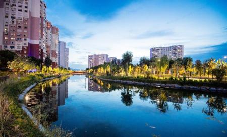
Izmir is a Turkish city with roughly 4 000 000 inhabitants. Located in the west coast of Anatolia, it is the country’s third most populous city. The local climate is Mediterranean, with long and hot summers and relatively mild winters.
Izmir is one of the oldest cities on the Mediterranean sea, with 8500 years of history. It is deeply cultured and offers a variety of historical sites. Izmir is also a modern and dynamic economical centre of its region. The local economy benefits from flourishing service industry followed by manufacturing and agriculture.
With its large population and expanding urban areas, Izmir offers an opportunity to apply European re-naturing strategies to cities facing the challenges of the fast urbanizing world. The interventions will focus mainly on creating green corridors and on decreasing the city’s temperatures.
Potential impacts/benefits:
- Renaturing urbanization
- Green route: By installing a new urban green cycle route within the new green route, an estimated number of 700000 citizens will be able to visit the green corridor including riverside restoration towards the Natural Life Park. 500000 more citizens are expected to benefit from this intervention using the BISIM public bike rental system.
- Arboreal interventions: It is expected to reduce the CO2 level to 46 tons of CO2 equivalent per year and reduce the influenced area’s ambient temperature by 3 to 5°C during summer.
- Resting areas: It is expected to provide shadow area in selected locations.
- Carbon capture and storage: It is expected to capture CO2 and to sequester an estimated amount of 36 tons of CO2 equivalent per year. It is also expected to increase biodiversity to the region.
- Water interventions
- Sustainable Drainage Systems (SUDs): It is expected to capture 165 tons of water per year.
- Flood actions: It is expected to prevent flash floods and to increase water retention capacity. Moreover, the concrete walls of the riverbank will be replaced by eco-friendly permeable materials. These are expected to add 300000 new urban dwellers per year.
- Green pavements: They are expected to reduce the ambient temperature by 2 to 4°during summer.
- Singular Green Infrastructures
- Biochar implementations: It is expected to reduce 1.05 tons of CO2 equivalent and 0.4 tons of NO2 equivalent level per year. Furthermore, it is expected to reduce the heat island effect by 1.5°C.
- Pollinators: They are expected to enhance the biodiversity within the area and are to be used for educational purposes. Pollinator activity is expected to increase by 45% thus, increasing the number of native plant communities.
- Vertical Green Infrastructure: They are expected to serve as a security against heavy rain falls and hence reduce the risk of flooding.
- Horizontal Green Infrastructure: A green covering shelter to be installed in the selected car parking areas is expected to provide water for plants, shade for citizens, and capture CO2. Moreover, pavements with a high albedo (solar reflectance) will be installed within the said parking area and are expected to reduce heat absorption and retention. The singular GIs(such as the covered shelter and shady structures) are expected to enhance the green cover by 75% and to reduce the ambient temperature by 2 to 4°C, and to reduce the organic gas evaporative emissions and NOx emissions by 2% and by less than 1% respectively. On the other hand, the pavements are expected to reduce by the heat of the surface by 10°C. An estimated number of 230000 people will benefit from the green shelter and the rest of the GI implementations.
- Urban farming: The expected impact includes producing 7.5 tons of water per year due to the water-resistant plants to be placed in the greenhouses.
- Non-technical interventions
- Educational activity: Different GIs are expected to improve the well-being of around 90000 citizens as well as their sensory qualities. Furthermore, an educational path to be installed in the Bio-boulevard are expected to attract over 150000 citizens and educate them on urban biodiversity, climate change, etc. In addition, a special educative and communication program will be taught as an open-air “laboratory of the future” to demonstrate the consequences of climate change. 840000 people are expected to visit the “Laboratory of the Future”. Lastly, a strong producer presence will be administered via producer stalls, women cooperatives, and aid from the local government. An estimated number of 420000 urban dwellers will be visiting these market stalls.
- Engagement: Knowledge transfer, supporting farmers’ welfare, encouraging women cooperatives, and organizing bio-blitz events at Izmir, are expected to allow a direct engagement between the citizens with the respective numbers: 50000 for the portal, 300000 for municipality-enabled urban farming, 85000 for the women cooperatives, and 100000 for the bio-blitz and open platform.
- City coaching: Awareness activities and mobile applications are expected to reach 500000 recipients with regards to ecological reasoning and intelligence
- Support activities: A new platform that facilitates monitoring of NbS solutions in the city and provides citizen support, as well as a city mentoring strategy will be made to allow an estimated number of 60000 recipients to engage in the project.
Actions:
nature based solutions
- Re-naturing urbanization
- Cycle and pedestrian route in green corridor
- Planting of trees and creation of arboreal areas and parks
- Carbon sink via the installation of urban woodland
- Water interventions
- Installation of grassed swales and water retention ponds for water storage and filtering
- Riverbank restoration and green pavements
- Singular green infrastructure
- Biochar production and usage
- Installation of several pollinator modules
- Installation of green fences
- Green covering shelters, cool pavements
- Construction of Greenhouses for educational purposes
- Non technical interventions
- Engagement of citizens in a variety of educational activities
- Support to participation of citizens to co-design activities
Contacts:
- Project Coordinator
- CARTIF Technology Centre
- Raúl Sánchez
- rausan@cartif.es
- Communication secretariat
- Fondazione ICONS
- Alice De Ferrari
- alice.deferrari@icons.it
MONITORING PROGRAM:
- Challenge 1: Climate Mitigation & Adaptation Monitoring Procedure
- Biophysical KPIs:
- Tonnes of carbon removed or stored per unit area per unit time (tonnes CO2/Ha) (tonnes CO2/year) and Total amount of carbon stored in vegetation (tonnes CO2/Ha) (tonnes CO2/year).
- The decrease in mean or peak daytime local temperatures (°C )
- Measures of human comfort e.g. ENVIMET PET — Personal Equivalent Temperature, or PMV — Predicted Mean Vote
- Heatwave risks (num. of combined tropical nights (>20°C) and hot days (>35°C)
- Energy and carbon savings from reduced building energy consumption (kWh/y and tonnes C/year saved)
- Tonnes of stored per unit area per unit time (tonnes CO2/ha) (tonnes CO2/year). Total amount of carbon stored in soil.
- Energy, Water, Carbon Reduction via Urban farming (Climate-smart Greenhouse)
- Biophysical KPIs:
- Challenge 2: Water Management Monitoring Procedures
- Biophysical KPIs:
- Drinking water provision (m3 ha-1year-1) and Water for irrigations purposes (m3 ha-1year-1)
- Runoff Volume Calculation (mm, m3 , m²)
- Biophysical KPIs:
- Challenge 4: Green Space Management Monitoring Procedures
- Biophysical KPIs:
- Production of food (tonnes/Ha/year)
- Increased connectivity to existing GI
- Pollinator species increase (number)
- Socio- Economic KPIs:
- Accessibility of urban green spaces for the population
- Weighted recreation opportunities provided by Urban Green Infrastructure
- Urban green spaces per capita
- Distribution of public green spaces/total surface per capita
- Biophysical KPIs:
- Challenge 5: Air Quality Monitoring Procedures
- Biophysical KPIs
- Annual mean levels of fine particulate matter (e.g. PM10) in cities
- Air quality parameters and trends in emissions NOx, SOx, PM10 etc.
- Pollutant’s removed by vegetation (in leaves, stems and roots)
- Biophysical KPIs
- Challenge 6: Urban Regeneration Monitoring Procedures
- Socio- Economic KPIs
- Accessibility: Connectivity, distribution, configuration, and diversity of green space and land use changes (multi-scale). - Green spaces quantity.
- Socio- Economic KPIs
- Challenge 7: Participatory Planning And Governance
- Socio- Economic KPIs
- Perceptions of citizens on urban nature - Green spaces quality
- Socio- Economic KPIs
- Challenge 8: Social Justice And Social Cohesion
- Socio- economic KPIs
- Green intelligence awareness
- Socio- economic KPIs
- Challenge 9: Public Health And Well-Being Monitoring Procedures
- Socio- Economic KPIs
- Increase in walking and cycling in and around areas of interventions
- Socio- Economic KPIs
- Challenge 10: Potential Of Economic Opportunities And Green Jobs Monitoring Procedures.
- Socio- Economic KPIs
- Number of jobs created
- Socio- Economic KPIs
NBS benefits:
- Developing climate change adaptation; improving risk management and resilience
- Reduce flood risk
- Increase Biodiversity
- Improve air quality
- Increase accessibility to green open spaces
Further information:
- URBAN GREENUP WEBSITE: https://www.urbangreenup.eu/
- URBAN GREENUP DELIVERABLES: https://www.urbangreenup.eu/resources/deliverables/
- D4.1, D4.3/D4.7, D4.4

